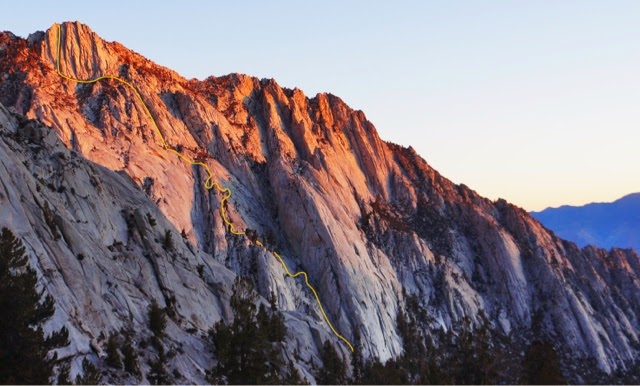
Ummagumma III-IV, 5.7 A0 or 5.9, 2'500ft
Wrinkled Lady- Whitney Portal, Lone Pine, Ca
F.A. Myles Moser 2010- 2013
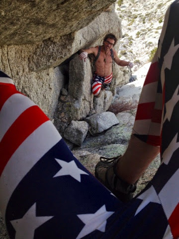
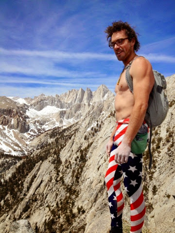
One step from the sliding glass door of the Whitney Portal Store kitchen shows it all! The looming pyramid of the south facing Wrinkled Lady, slashed with dihedral after dihedral stands at its tip of 10'900+ ft. Below it, a system of slabs, terraces, dikes, tunnels and a massive five hundred foot dihedral, make up its foundation, right off the main trail. Over a course of three years I carried rocks while climbing to stack cairns in strange places for future followers. Down soloed wrong turns, battled foliage, built monastery steps and at times kicked over my own rock stacks. Friends would join in the effort of perfecting this adventure big wall with me. We would get lost together in the unknown. Then once the route had been finished, I often found myself racing the clock to be at work by noon (usually late), pushing the final 500ft dihedral then charging down the scree decent; showing up sweaty and torn to the restaurant kitchen, just in time. This, is to be an adventure...
The 2'500 foot "Royal Arches of the Portal" begins by romping up the polished gully to the left of the Whitney Portal Buttress, don't move too fast its about to be a long one. A quick, slick lie-back will bring you to a humongous house size chockstone. Traverse to the left, under the chock; following a catwalk past "The Lonely Lone Pine". Remember to keep an eye above for a fixed pendulum. Take an exposed undercling and shimmy out to the penji. Swing wildly to the horn! Rock some slab moves to a two foot wyde grassy ledge. Walk it to the right; where a black swirly dike turns up the slab leading to the "Three Tree Terrace". Follow cairns and steps to a broken dike climbing the vertical wall, that quickly turns to a slab. Now at the "Second Terrace", take more monastery steps that head up and over a shrubby bump to the west. Follow the obvious path under the chicken-head wall to the "Dead End Log". Climb the knobby arête above the log to a cave on its left. Wiggle and worm through the choked cave to a tunnel on the left side. Boulder up the arête through leaning blocks to another slot/chimney with a thin leaning flake. A giant pine then marks the "Third Terrace" (Gettin' complicated yet?), slip n' slide through the "Pine Needle Chasm" on the trees right. Take the only way out, up an arching slab, exiting through a slight overhang on climbers right. Follow the cairns left and up to the "Turquoise Chicken-heads". Jog left on the heads to another tunnel through; squeeze behind what resembles a "Wooden Power Pole"? An obvious short downclimb to the west will drop the climber at an "Earlobe Undercling" that moves left past some water pods. Gain the arête directly above, via some quick knob climbing. Once again the arête morphs into a 200 ft slab with a big wide lie-back on climbers left, which abruptly ends at a vertical wall. Span the gap on the right, making way up a wyde-span to slab; gain the ridge on climbers left and marvel at the views below. Follow the cairns to the "Fresh-air Traverse"; where wildly exposed, yet secure moves venture to the west. Finish through an incredible water groove for 100ft, ending at the "Fifth Terrace", where the first of two massive southwest facing dihedrals takes off (A giant cairn marks the base). Get creative in the corner, seeking the path of least resistance. When it begins to get steep, dive into the belly of the beast and tunnel for the light. Nearing the end of the corner, a "Bushel Grab" strung tight with cord must be made. A shattered gold dike will lead to more water pods, then over a final chockstone to small manicured terraces known as the "Terrorist Hang". Now, the south face of the Wrinkled Lady suddenly comes into view. A Short scramble to the base, will give way to an easy walk to the west (follow cairns). Pass under the center dihedral (5.8 A2) capped with steep roofs, which had Fred Becky stating "rough unglaciated rock surface and very deep cracks conspired to scrape hands and knees and to tear clothes in serious struggles with cracks" (AAJ Volume 18 pg.120). Well, this won't be the case. Keep moving left along the base to the last massive dihedral on the wall, two large cairns mark the start. Enjoy this easy system of bomber cracks, till once again you dive into the belly of the giant when the wall becomes overhung. Tunnel through, then onto a chockstone, look for the knob on left then continue upward. The final small chimney at the end of this five hundred foot corner, will give you the thrill that you have been looking for, when you look down through your legs and catch all that exposer you had been chasing!
Descent: descend down the west ridge of the Wrinkled Lady to a 4th class gully down climb. Head west to the Pinyon Pines, to a massive sand slop. Follow the slope to a large boulder drop-off, which has a fixed rope for the short down climb. Take deer paths down the Carillon drainage to main trail (Don't get sucked to close to the creek or shwacking may in ensue).
Ummagumma is the name of a Pink Floyd Album, when defined by Urbandictionary.com it states that the word is "a slang term for having sex. And of course Rock and Roll was originally slang for having sex". So, if you look at it that way, the word Ummagumma could simply mean... Rock and Roll!