Mt. Whitney Webcam 1

Webcam 1 Legend
Mt. Whitney Webcam 2

Webcam 2 Legend
Mt. Whitney Timelapse
Owens Valley North

Owens Valley North Legend
Owens Valley South

Owens Valley South Legend
Previous Thread
Next Thread
Print Thread
#47488 05/20/08 01:23 PM
Joined: Aug 2006
Posts: 2,391
Member
Member

Joined: Aug 2006
Posts: 2,391
Mike, Cori, and I had been slated to make a run up Candlelight Peak on Sunday, but some last minute tweaking took us back to the MR! I wasn't sure how far I'd get, having climbed Mt. Agassiz Saturday (TR later), but I was definitely motivated to hit it with Rick Graham, Bob, and the guys. So after a decent sleep, a few chocolate covered espresso beans, and a shot of Glenfiddich (thanks, Rick, for the housewarming gift!!), we hit the trail at 0515.

A lot changes in 3 weeks:

1)The snow bank below LBSL is gone. Trail is dry and clear and the waterfalls are running fast, strong, and yummi!

2) While the snow is still mostly viable on the slope up to Clyde Meadow, the traverse around the south end of the lake is postholey, even at 7:30-8 a.m.!!

3) The slabs below Clyde Meadow are a nice walk-up, but do watch your footing on the wet rock .

4) UBSL looked still frozen over, but I heard you can chop through easily.

5) The snow heading up from UBSL is again, mostly firm, and the heat wave from the weekend I think softened things up considerably. We were able to stay on top most of the time, but just headed high on the rock as much as we could.

6) The waterfall route was still pretty easily negotiated below Iceberg. However, the scree slope above it was a giant PITA, and I should have gone with the guys around the far side. I was able to kick in steps on the snow below it, but crampons would have been a nice idea.

7) The snow in the chute wasn't bad... don't mind the blood trail I left in my kicksteps! We were able to walk pretty well straight up the right side, although old boot track/footsteps were melting out and hard to see entirely.

8) The left side route we came up was cool, and the right looked pretty clear as well.

9) 72 degrees on the summit??? Are you freakin' kidding me???

10) Descent was a blast: we hit the snow slope just as it came into shadow, but wouldn't have wanted to be much later. I glissaded down... in shorts. My butt still hasn't fully thawed!

11) First burger post-Whitney summit this year. Hopefully many more to come!

Thanks to the guys for inviting me along for the ride. I had a blast!

Rest of the pics are here.

-L cool

PS: The wagbag I shot pics of three weeks ago was still on the summit. So I borrowed garbage bags to haul it down, but Graham though it might tear, so he stowed it in his pack. BIG TIME KUDOS to him for carrying down someone else's crap .

PPS: Rick Lovett and I found another fire ring , this one just above the trail at LP Lake. I was too tired to dismantle it, but I'll be back to take it apart, unless someone beats me to it!

A few other images from the day:

Work it! Work it! You still don't get a peanut.


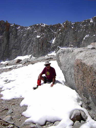
A little stuck:

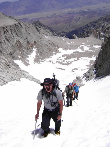
My train as I kicked steps:

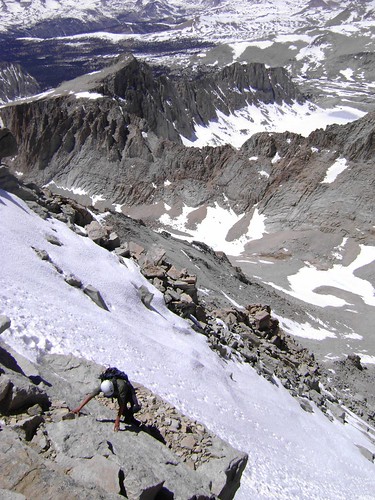
Left-side:

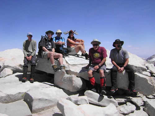
Summiteers:

Flickr Pics

Think outside the Zone.
Joined: May 2008
Posts: 7
Member
Member

Joined: May 2008
Posts: 7
hey thanks for the calming words on your way down the glissade chute. my girlfriend was so nervous post-holing down. finally made it down, and it only took (3) hours! at least i was able to run some self-arrest practice and glissading with her toward the early evening. damn! my butt is still thawing. i'll post some pics too! we had great weather that weekend!

Joined: Aug 2006
Posts: 2,391
Member
Member

Joined: Aug 2006
Posts: 2,391
Ryan and Danielle, congratulations on your summit! smile Like I told you, my first glissade was this past winter, and that slope is a tricky place to learn! We were watching you guys as we descended through Trail Camp, thinking your poor butts were solid ice themselves! shocked

Tell Danielle that when I was glissading in the Baldy bowl this past February, I stopped midslope, laughing hysterically. A few in our party who were skiing down on the opposite side of the Bowl said they could hear me all the way across! Talk about pure, unadulterated joy!!! grin It does get fun when you practice!

Congrats again!

-L cool


Flickr Pics

Think outside the Zone.
Joined: Jul 2006
Posts: 629
Member
Member

Joined: Jul 2006
Posts: 629
Awesome Pics. Hey Mike saw your car in the parking lot, Doug said to look for you on Sunday. What time did you summit. We topped off around 9:30am. Looked for you on the 395 expecting you to pass us up.....

We camped at Trail Camp so got a head start. If people are going up the chute on the MT need an early start. Glissading down was a blast, saved over an hour on the trip. Conditions change daily so be careful....

Joined: Sep 2003
Posts: 337
Member
Member

Joined: Sep 2003
Posts: 337
Sounds like you've really been getting out lately Laura. Congratulations on a great outing. 72 degrees on the summit! I'm jealous. But not so jealous about that glissading in short pants part... I may be up your way some time in June. If so I'll let you know.

BTW: Things have been really hectic the last few weeks. Sorry I didn't call you back. The SPRI class was great. Got my cert. WFR too. Carry on!

Joined: Jun 2003
Posts: 142
Member
Member

Joined: Jun 2003
Posts: 142
thanks for posting your great picks. I like marmot, it looks so funny.
Cheers

tomi #47521 05/21/08 02:17 PM
Joined: May 2008
Posts: 6
Member
Member

Joined: May 2008
Posts: 6
Sounds like you had a great trip!

Any advice on where to camp if doing an overnighter (i.e. UBSL, Iceberg). Also, do you advise descending back to camp via the MR or take the MWMT back down? If the MWMT, are there any issues getting back to camp from the Trailcamp area back to UBSL or Iceberg? (see thread Mountaineer's Route).

Your photos were great, and they really speak for themselves regarding conditions. Any issues at the creek crossings?

Thanks!

Joined: Jun 2003
Posts: 89
Member
Member

Joined: Jun 2003
Posts: 89
If you are heading up soon, you can camp either at Iceberg Lake or Upper Boy Scout Lake. Both would have dry areas on the eastern sides to camp on.

Unless you are day hiking, coming down the regular Mt. Whitney trail is not a good option. Getting back from Trail Camp to Iceberg Lake or Upper Boy Scout Lake would require a trip over the Pinnacle pass. http://outdoors.webshots.com/photo/2028353340061435028GaGzGH

It is possible, but such a trip is way out of the way, and would add 3-4 hours onto your hike to the summit.

Usually the creek crossings are not bad, even early in the year when the river is flowing fast.

Joined: May 2008
Posts: 6
Member
Member

Joined: May 2008
Posts: 6
Thanks for the info.

Great photos from Moosetracks! We're just a day away from being able to see this stuff for ourselves.


Moderated by  Bob R, Doug Sr 

Link Copied to Clipboard
Mt. Whitney Weather Links


White Mountain/
Barcroft Station

Elev 12,410’

Upper Tyndall Creek
Elev 11,441’

Crabtree Meadows
Elev 10,700’

Cottonwood Lakes
Elev 10,196’

Lone Pine
Elev. 3,727’

Hunter Mountain
Elev. 6,880’

Death Valley/
Furnace Creek

Elev. -193’

Powered by UBB.threads™ PHP Forum Software 8.0.0
(Release build 20240826)
Responsive Width:

PHP: 7.4.33 Page Time: 0.051s Queries: 34 (0.032s) Memory: 0.7386 MB (Peak: 0.8226 MB) Data Comp: Off Server Time: 2025-04-06 03:21:58 UTC
Valid HTML 5 and Valid CSS