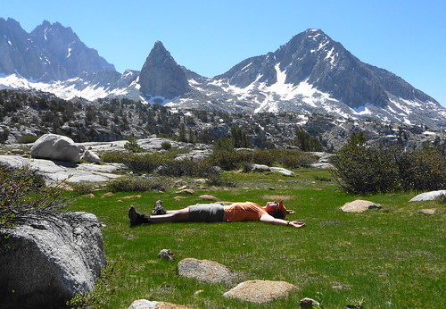
A flat-topped boulder should never be left on the side of the trail, in a meadow, in direct sunlight where gentle rays could induce long, high altitude naps. The Park Service may as well install a sign that says, "Nap Zone" beside Big Pete Meadow, and ropes to guide weary travelers to the rock. I didn't even take my pack off: just leaned back and closed my eyes, drifting off into happy slumber as birds flit about the meadow and bees zipped among the flowers. You can't beat paradise.
Day 1: A Long Walk.The chilled air at South Lake on Friday morning tickled the hairs on my arms,
frost tinging the ground cover as I made my way along the Bishop Pass trail. Plans had changed for the holiday weekend, so now I was heading out on a solo adventure, and the loop between North Lake and South Lake had been in my radar for a while. Most people, I believe, take about a week to run the loop, and I had three days, plus the peak-bagger in me had zoomed focus on the many peaks in the region which I had stared at last year while climbing Mt. Goddard and The Hermit. So the route would follow the trail for the first day, then cut the loop a bit short to get back to Humphreys Basin via Alpine Col. Not a bad plan, just an aggressive one.
The air was clear, the wind brisk as I topped out over Bishop
Pass , still under a fair amount of
snow despite melting out quite a bit since being there with my Pop a few weeks ago. The north chutes of Mt.
Agassiz still held snow in the shadows, and the rest of the
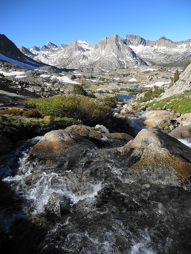
Palisades , purple in the morning sun, emerged as I strolled down through Dusy Basin. Tumbling brooks and cascades formed a tangled web on both sides of the trail, an occasional
lake hiding behind a slight undulation in the rocks. Wet, emerald meadows of short, sharp grass begged to be run through or
rolled on, the pungent smell of moist earth and spring permeated the air. I strode down along the water courses, the Dusy Branch converging and quickening as I reached the drop to LeConte
Canyon .
A few thousand feet of
air greeted my gaze from the lip of Dusy Basin as the creek roared over the edge and plummeted to the canyon below. I had only seen this drop from the summit of Mt. Agassiz, and marveled even then, but the severity of the chasm took my breath away. Polished granite and angular peaks, cascades tumbling white against the far wall, towering pines lining the floor. By now the wind on the pass had dropped to a whisper, teasing and daring me to take the steps down and away. The trail wound back and forth along the face as I descended, in and out of aspen groves and pines, crossing and recrossing the cascade. There really seemed to be no bottom to it, and then, the river. Near the ranger station, I threw my pack against a tree and dug in for lunch, the mosquitos kept at bay for the moment by the light breeze.
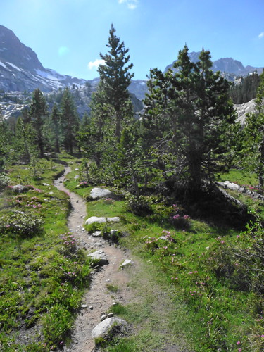
The JMT north through LeConte canyon is wooded and soft-packed
dirt , the many mud zones a testament to the recently melted snow and high water. To the west,
Langille Peak's smooth granite walls tower overhead, ribbons of cascades streaming from unseen snowfields and lakes on its flanks. Ever so gently, the trail
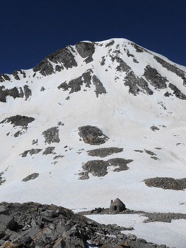
winds up through the forest, occasionally giving way to Little Pete and Big Pete Meadows (ie: the Nap Zones). While there was no snow here, a warning
sign around 10.5K recommended making camp near the river due to conditions higher up. My objective had indeed been Helen Lake, but with the afternoon sun shining warm on the nooks in the trees here, I decided to call it a day, and tucked my bag in under some
pines . After a relaxed evening, I stared up at the east face of the
Black Giant , the last rays tinging the north ridge gold before I closed my eyes for the night.
Day 2: Up, Over, and Slide.After coffee and oatmeal in the morning, I sidled out onto the trail once again, just behind some PCT hikers who had also crashed at the site. It was another crisp morning:
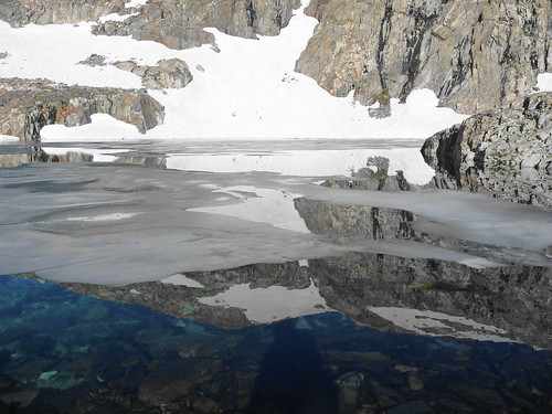
ice had formed in the trail and along the lake edges as I ascended Muir Pass. A wall of
snow greeted me around 11K, and was consistent the rest of the way up to the Pass. Thick snow
bridges crossed and recrossed the river, the upper lakes, and especially
Helen Lake , still mostly frozen. The snow was firm in the morning sun, but there was plenty of evidence of afternoon crossings and postholes all around. Strangely enough, most of the higher reaches held no snow, except for
Mt. Solomons , immediately above the pass. I longed for a pair of boots, as I had on trail runners, so that I could throw on my crampons and walk up the snow fields to the summit of Solomons, but instead I simply soaked in the scene at the
Hut with other travelers at this well-known crossroads.
I was done with the trail.
The
ridge to Mt. Warlow heads NNE from Muir Pass, a tangled, steep jumble of rock and sand. "You're going up there?" I was asked. "Why?" Honestly, I've found it's best to just shrug and smile since trying to actually explain the obsession would not only take hours but would fall on deaf ears. With the full pack slung over my shoulders, I leaned into the slope and slowly made my way over the loose rocks of the ridge towards the summit. In looking back, the Hut never seemed to get any futher away, but I kept trudging and picking away at the ridge until, suddenly, every point angled
down from all sides. Mt. Warlow's south face plunged directly to
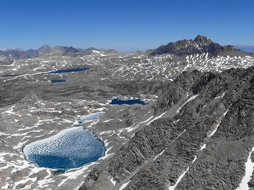
Helen Lake , two ridges extended to Mt. Fiske and
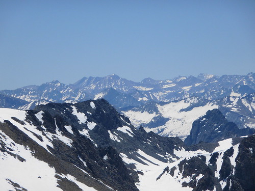
Huxley , forming the cirque that cradled the Warlow Glacier to the north. I scanned the panorama, the Darwin wall to the north, Mt. Goddard towering to the west, Scylla guarding the Ionian Basin to the SW, the entire LeConte Canyon to the SE, and the Palisades darkening the eastern horizon. Far to the south, the northern chutes of Whitney still held their snow, and I smiled at my old friend so far away.
I had originally intended to scramble the ridge to Mt. Huxley, then descend the west face chutes to the trail and follow that to Evolution Lake. However, the ridge, while rated Class 3, looked stout and moderately exposed, not something for me to be hitting with a full pack and alone. My eyes wandered, searching the scree below as it delved back to Wanda Lake, then passing to the north and the
glacier . A light bulb popped into my head (always an eyebrow raiser) about looking for the access to the glacier and heading across the basin to Mt. Spencer. The low spot on the ridge to Huxley provided the chute of loose
scree for about 100ft, then the steep snow of the glacier began. I was already wearing my helmet from the ascent, and I sat to don crampons and pull out my axe as I prepared to plunge step the upper glacier before considering a glissade. The snow seemed in fine condition: no discoloration, a few small slides to the north, no cracks or bergshrunds with which to deal. I dug in my heel, touching the surface with my axe for balance as I began the descent. Right... left... right...
Gone.
I was sliding down the glacier, my feet swept out from under me by some unseen ice or sloppy snow. I leaned left, trying to drive the pick of the axe into the snow, but to no avail. Shit, shit, keep your feet up, dammit: don't catch a crampon. I had joked with a friend on the westside SAR about never putting them in a bad position, and I wasn't going to start now. I pulled the axe in, and muscle memory kicked into gear as I wrenched myself onto my stomach to the right. The axe bit for just a second, almost pulling itself free of my grasp as I continued to slide, knees bent, resisting the urge to drive my feet into the snow. I reached the lessening of the angle in the snow, and I could feel myself slow just a bit as I muscled the axe into a better position, my knuckles burning from the friction on the snow. I finally came to a stop about 150ft after the start of the slide (perhaps more, I'll have to look at the pictures and measure it against a topo). I was shaking a bit from the adrenaline and fear, but when I looked around, saw that the base of the glacier was a benign bowl, no rocks to be seen, no cliffs to tumble over, I turned, sat down again, and finished the
glissade . At the base of the glacier, I sat and stared at the walls around me, thankful that I had practiced those skills when I could. A tumble there could have really hurt.
The headwall of the cirque dove to a high
basin of lakes and meadows, a perfect spot for lunch. I napped (see, I WARNED you about flat rocks in the sun in a meadow) in the quiet breeze and sunshine among red heather and babbling brooks, then loaded up once again for one more climb up the southern slopes of
Mt. Spencer . A Class 2 scramble led to the summit ridge, whose tedious
boulders presented more annoyance than anything in getting to the summit. But this is the Thor Peak of Evolution Basin, perched in the amphitheater beneath quiet
giants and above deep, silent lakes, their surfaces broken by brushed ice. The wind was calm here as I perched on the summit blocks, breathing in the afternoon sun and smiling at the expanse. The north face provided a Class 3
ledge system for the descent, only forcing me onto the snow once near the base, then onto sloping slabs leading to the southern
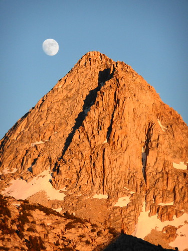
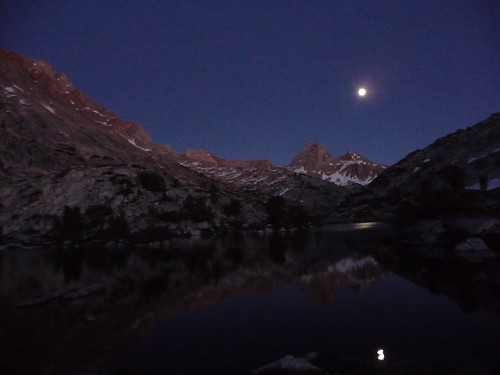
shore of Evolution Lake. I joined the trail, striding out the last mile of the day to the same slab outcropping where I had camped with my friends a year ago. After a running dip in the lake (waving frantically at the mossies which swarmed as soon as I stopped), I sat and watched an almost
full moon rise above Mt. Spencer. Within a few minutes, nature's fireworks of deepening alpenglow emerged, and I celebrated independence and freedom as the breeze sent ripples lapping along the shore.
Day 3: Slogging HomeAfter a cold night (really should have brought the 15 degree bag), I stumbled up to make coffee and breakfast. My pack loaded once again, I crossed the slabs on the north side of the trail to ascend into the
Darwin Basin , a simple effort of only a few hundred feet along the double waterfall plunging into Evolution Canyon. Every once in a while, I would turn and grimace at
The Hermit , remembering the chute of death through which I had to be belayed last year. But I was drawn back into the greenery and creeks of Darwin Basin, ignoring the turn up to Lamarck Col and instead maintaining a northerly course towards Mt. Goethe and Alpine Col. The lower waterways posed little problem or effort to cross, and the slabs made for a lovely
stroll to the first of the unnamed lakes in the basin. The western shore was a scree mess, loose rock plunging down to the lake and making the scramble up to the peak look remarkably unpleasant. A bare
rib of jumbled rock, resembling the North Rib of Tyndall, was exposed from snow and I aimed to get to it. My path around the eastern shore, however, was blocked by
steep walls of snow, slightly suncupped and slick in the midday sun. I donned crampons once again, and headed out across the traverse. Sometimes, I really just shouldn't look
down . Fifty feet below me the waters of the lake shimmered sapphire blue, but then I noticed the complete lack of rocks and the water diving to at least 20 feet in depth. Not the optimal place to slide on consolidated snow. I angled my steps up the slope to ensure a stiff bite with my crampons and didn't stop moving, despite complaining legs. Descending to the rocks on the far side, I breathed deep and finally dropped the pack to scramble up the rocks to the summit of Mt. Goethe.
A thousand feet of scrambling left me
breathless , as did the view from the top. To the NE, Mt. Humphreys rose towering over his basin, and I got my first look at the far side of Alpine Col, which, I admit thinking, didn't look too bad. Nope, wrong. I was about to enter boulder hell. After descending to my pack and the lakes (staying high is fruitless unless you are all the way on top of the ridge), I was forced into a
rhythm of crampons on, crampons off, boulder scramble in between. I crossed one recent, enormous rockfall, grit and sand still coating the tops of the rocks, the ice of the lake buckled and twisted from the showering. Once again, don't stop moving. I grimaced at the Col rising a few hundred feet above, snow cresting the saddle. The initial descent wasn't indeed bad at all, a few short glissades on soft snow between rocks. I suppose I should have stayed high above the shore, but I needed water anyway, so like Alice in the
maze I ducked, pulled, jumped, balanced, and swung my way through the house-sized boulders. I finally stopped looking at my watch to see how much time I was wasting hidden there. "Not even the bright orange would help you here," I thought to myself as I picked my way across. I cried out to Humphreys to throw me a line when he finally came into view.
At long last, flat ground and the overlook to
Muriel Lake . To my
right , more steep snow slopes and deep waters to traverse. To my left, a more gradual and seemingly snow-free landscape. I went left. Four THOUSAND miles later, after the lake kept opening up to the left, and in and out of lonely drifts of suncupped mush, I finally walked across the flats to
Piute Pass . My stride opened, I as much closed my eyes, and my feet brought me home in the deepening afternoon warmth, ending my solo celebration of the right to kick my own ass.
A few highlights:
Pics are here:
Day 1 Day 2 Day 3 From the luckiest girl in the world: Climb Hard, Be Safe.
-L


