Mt. Whitney Webcam 1

Webcam 1 Legend
Mt. Whitney Webcam 2

Webcam 2 Legend
Mt. Whitney Timelapse
Owens Valley North

Owens Valley North Legend
Owens Valley South

Owens Valley South Legend
Previous Thread
Next Thread
Print Thread
#74248 03/22/10 07:00 PM
Joined: Dec 2006
Posts: 89
Member
Member

Joined: Dec 2006
Posts: 89
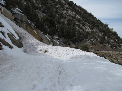
Snow is continuous above the first stream crossing in the North Fork. Road access ends a little after the big switchback due to a large wet slide (
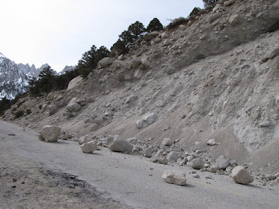
ESAC mentioned the possibility in the Thursday forecast, when it happened). There are the usual large boulders in the road above the second bend.


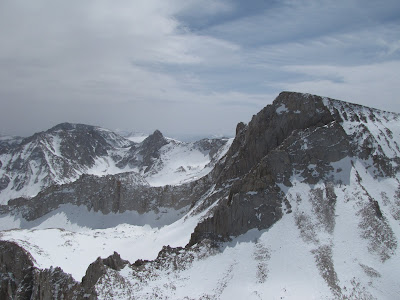
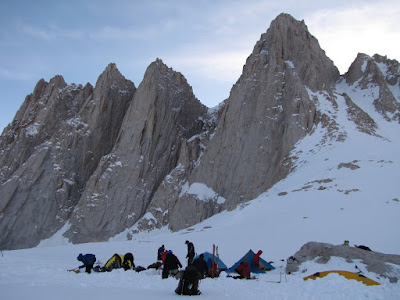
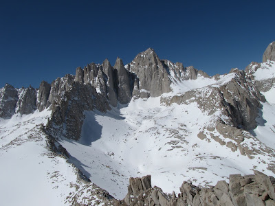
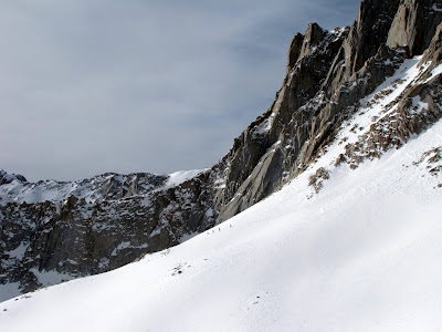
The boot pack to the summit is firm and snowshoes are not required unless you venture off-trail. The skiing in the couloir (only did the part below the notch) was crappy, but below Iceberg it was excellent. Here are some Whitney pictures from different vantage points:


The rest of the pictures are here.

Last edited by hamik; 03/22/10 07:01 PM.
hamik #74296 03/23/10 05:36 PM
Joined: Dec 2002
Posts: 961
Member
Member

Joined: Dec 2002
Posts: 961
Your pictures just blow me away! They are so wonderful, and show a familiar landscape in such different and interesting ways!
You guys really accomplished a lot in a weekend, esp. in winter!
Thanks for sharing such beautiful and stunning pictures.

CaT

hamik #74320 03/24/10 05:57 AM
Joined: Aug 2003
Posts: 492
Member
Member

Joined: Aug 2003
Posts: 492
Nice pics, hamik. I'm surprised I didn't run into you on Saturday.

Joined: Dec 2006
Posts: 89
Member
Member

Joined: Dec 2006
Posts: 89
Based on your summit time, I think I was using Ye Olde Wag Bag at Iceberg while you started up the couloir. In any case, what an awesome day! The next day got really windy...

Thank you, trailwalker. Much of the motivation came from my indefatigable friend, The Kedrone v. 4.25.

Last edited by hamik; 03/24/10 09:59 PM.
hamik #74389 03/27/10 04:50 AM
Joined: Oct 2009
Posts: 79
Member
Member

Joined: Oct 2009
Posts: 79
That was a productive few days. Nice photos too.

hamik #74409 03/28/10 10:25 AM
Joined: Jan 2010
Posts: 16
Member
Member

Joined: Jan 2010
Posts: 16
Thanks for the post Hamik. What time did you ski the chute? I am heading up there soon to climb abd ski it and have been wondering what time the chute softens up. Any suggestions...Thanks,

Last edited by Andrew Gundershaug; 03/28/10 10:26 AM.
Joined: Dec 2006
Posts: 89
Member
Member

Joined: Dec 2006
Posts: 89
Depends a lot on weather... if it's windy it just won't ever soften up, and there isn't enough loose snow to blow in and make it wintry (this might change after Wednesday). When I skied it there were wind features and boot holes which made it difficult for a relatively novice skier like me. Maybe someone else can comment?

hamik #74437 03/29/10 03:20 AM
Joined: Jun 2003
Posts: 5,437
Likes: 9
Member
Member

Joined: Jun 2003
Posts: 5,437
Likes: 9
The MR is one of those ski rides that you tick off of your list. The skiing is rarely any good in the couloir and down lower, it can be thick and heavy a lot of the time. Of the times I've skied the NF, only once did I get the feeling that I was in heaven.

Ask Kurt, or any of the other BC Regulars for recommendations on much better places to ski.

Joined: Jan 2010
Posts: 16
Member
Member

Joined: Jan 2010
Posts: 16
Richard,

It is on the list. Epic or not it is skiing down Whitney. Thanks for the info,


Moderated by  Bob R, Doug Sr 

Link Copied to Clipboard
Mt. Whitney Weather Links


White Mountain/
Barcroft Station

Elev 12,410’

Upper Tyndall Creek
Elev 11,441’

Crabtree Meadows
Elev 10,700’

Cottonwood Lakes
Elev 10,196’

Lone Pine
Elev. 3,727’

Hunter Mountain
Elev. 6,880’

Death Valley/
Furnace Creek

Elev. -193’

Powered by UBB.threads™ PHP Forum Software 8.0.0
(Release build 20240826)
Responsive Width:

PHP: 7.4.33 Page Time: 0.101s Queries: 34 (0.082s) Memory: 0.7314 MB (Peak: 0.8077 MB) Data Comp: Off Server Time: 2025-04-17 19:22:51 UTC
Valid HTML 5 and Valid CSS