|
|
|
|
Joined: Aug 2006
Posts: 945
Member
|
|
Member
Joined: Aug 2006
Posts: 945 |
This years total in Mammoth is over 540 inches like it was a few years ago. Then, it made high passes like JMT's Muir Pass a postholing slog for many miles even into August.
Does anyone know if this years snow is a local Mammoth phenomenon, or has it affected further south?
I wonder when the PCTers will be going through there?
I know it is early to predict for later, but in August I'll be doing Kearsarge/Glen/Rae Lakes/Glen/Forester/Whitney. Thanks, Harvey
|
|
|
|
|
Joined: Dec 2003
Posts: 447
Member
|
|
Member
Joined: Dec 2003
Posts: 447 |
 Doesn't get any further south than this. Mt Baldy just below the summit, coming out of the bowl on a 70+deg day last Sat. This year, it's not just for Mammoth.
|
|
|
|
|
Joined: Jul 2006
Posts: 629
Member
|
|
Member
Joined: Jul 2006
Posts: 629 |
I"m totally guesssing but you should be good, especially if it's mid to late August. Sounds like an awesome trip be sho to post a TR on this site when you do it!
Yetidude.
|
|
|
|
|
Joined: Jan 2003
Posts: 2,446
Member
|
|
Member
Joined: Jan 2003
Posts: 2,446 |
Harvey, it's hard to know. I'll be up at Kennedy Meadows for a week, starting tomorrow, doing dayhikes from there. We were going to do a trip 9 miles north, but had to cancel due to the snow. Here is the snow graphs for Ca. The lower one is the only one relevant to this, I believe it covers Yosemite to Isabella. http://cdec.water.ca.gov/cgi-progs/products/PLOT_SWC.2010.pdf
Last edited by Ken; 05/01/10 04:52 AM.
|
|
|
|
|
Joined: Jan 2003
Posts: 2,446
Member
|
|
Member
Joined: Jan 2003
Posts: 2,446 |
From the NPS website: Tioga Road: Tioga plowing operations were halted due to wet slab avalanche activity at the South Fork avalanche zone. With freezing temperatures forecast, plowing ops are expected to resume today. 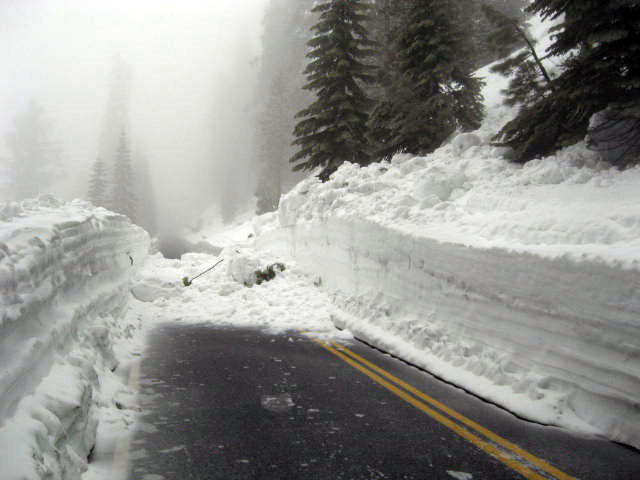
|
|
|
|
|
Joined: Sep 2005
Posts: 154
Member
|
|
Member
Joined: Sep 2005
Posts: 154 |
I did all of those passes except Kearsarge in the first week of August,'06 which was another wet year up there. All were safely passable sans crampons or an axe with little postholing. My main concern was not the passes but canyons. High runoff made some stream crossings a little hairy.
But that was '06, I haven't compared the snow levels and there is no way to predict the rate of thaw this year. Just food for thought. YMMV
|
|
|
|
|
Joined: Jun 2007
Posts: 18
Member
|
|
Member
Joined: Jun 2007
Posts: 18 |
If you go to postholer.com, you can read the PCT'ers' journals. They're having trouble even getting past Idyllwild.
|
|
|
|
|
Joined: Aug 2006
Posts: 945
Member
|
|
Member
Joined: Aug 2006
Posts: 945 |
Thanks for all the replies. Picture here is from 7/21/05- even simple Donahue Pass was covered although not any difficulty. 2005 was a relatively comparable snow year although this year will not be quite as much and I will be a week or two later. As everyone here knows, its' not just the amount of snow, but the weather that follows and determines the melt rate.  Uploaded with ImageShack.us
|
|
|
|
|
Joined: Dec 2002
Posts: 1,871
Member
|
|
Member
Joined: Dec 2002
Posts: 1,871 |
In SoCal, there was a lot more snow on Mt. Badden-Powell today than there was 4/4 a year ago. There is at least 3'+ of compacted snow on the summit. My guess is things are going clear late.
|
|
|
|
|
|
|


