|
|
Joined: Mar 2008
Posts: 46
Member
|
|
Member
Joined: Mar 2008
Posts: 46 |
Are there many river/stream crossings on the JMT? I know some of them are bridged, but was wondering about the depth of the unbridged ones during August?
Thanks.
|
|
|
|
|
Joined: Jul 2003
Posts: 1,190
Member
|
|
Member
Joined: Jul 2003
Posts: 1,190 |
I don't have a count, but there are quite a few unbridged stream crossings. Many are pretty trivial, but several are "interesting" at times. When we did the JMT in late July of 2006, Bear Creek and Evolution Creek were memorable. We crossed at the trail but ran into people who detoured a bit to find easier crossings. Had they been much higher, we would have chosen that option. One certainty: you will be getting your feet wet.
|
|
|
|
|
|
Anonymous
Unregistered
|
|
Anonymous
Unregistered
|
Alan, did you take sandals, or wade bare foot, or what when you crossed the streams?
I can't come up with a best option -- Teva's add a lot of weight to the pack, flip-flops seem too flimsy, and I don't really want to wade in with boots on.
|
|
|
|
|
Joined: Mar 2003
Posts: 838
Member
|
|
Member
Joined: Mar 2003
Posts: 838 |
Last time I used those "crocodile" shoes. they're super-lightweight, but they're much more substantial than flip-flops.
They have a strap across the heel, so I didn't worry about losing them while crossing streams; I used 'em for my camp shoes as well. I was pretty happy with them, and plan to use 'em again this summer.
Oh yah... they float too, if you drop 'em in water.
"What we have done for ourselves alone dies with us; what we have done for others and the world remains and is immortal." Albert Pike
|
|
|
|
|
Joined: Jul 2003
Posts: 1,190
Member
|
|
Member
Joined: Jul 2003
Posts: 1,190 |
Alan, did you take sandals, or wade bare foot, or what when you crossed the streams? We had those slip on watersports shoe that weigh almost nothing. They are ok but kind of thin. Rosabella's solution is more durable. Eric actually went barefooted for the first few, until he did some damage tothe bottom of one foot. After that he took the conservative approach.
|
|
|
|
|
Joined: Jan 2007
Posts: 57
Member
|
|
Member
Joined: Jan 2007
Posts: 57 |
My memory isn't so great, but I think I could count the bridged crossings on one hand. A few of them do have logs, rocks, and debris piles that are almost like bridges.
I crossed Evolution and Bear barefoot, but I won't do that again. I'll probably just charge through in my trail runners next time.
Early season of last year (low year) Bear Creek was the worst, but not that bad. The mosquitos were the worst part. Evolution wasn't bad. It can usually be deep and wift from what I hear. It had a nice smooth bottom. Apparently there was a tough crossing near a waterfall just north of VVR, but I must have hopped right over it. I had a much more difficult time on the High Sierra Trail. Evolution canyon basically has a lake ford, but you can rock hop it and keep your feet wet if the water is normal. Oh, and Tyndall Creek can be tricky. It's narrow but rough and has lots of vegetation. I didn't even get my feet wet on Upper Wallace. Lower Wallace darn near killed me though (on the HST).
Last edited by TwoFortyJeff; 04/10/08 11:43 PM.
|
|
|
|
|
Joined: Jan 2003
Posts: 2,446
Member
|
|
Member
Joined: Jan 2003
Posts: 2,446 |
Are there many river/stream crossings on the JMT? I know some of them are bridged, but was wondering about the depth of the unbridged ones during August? I'm giving the presentation on stream crossings for the folks doing the whole PCT, in a couple of weeks, as I have the last two years. As such, I've researched this, and talked to a lot of people, including the rangers who work the backcountry of the involved areas (I'm a volunteer ranger for the area that involves Bear Creek) By August, you should really have no problems. You may have to get substantially wet, but you shouldn't be in rushing water, and deep. Right after a storm, many of the crossings are raging, but they drop rapidly, often in only a couple hours. Here is what you are likely to encounter at Evolution Creek. The best crossing is reputed to be about 1/4 mile above the actual trail crossing: 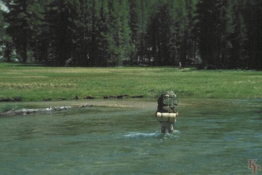 The other spot that is consistantly mentioned is the Bear Creek crossing, which should also not be a problem at the time you are talking about:  Stream crossings are probably the most dangerous thing involved in such a trip, and it is a bad idea to cross barefoot, based upon experiences I've heard, and it is a good idea to do it with hiking poles, or streamside branches, which tremendously help balance, and help you assess depth. many people take off their socks and insoles, then wade in their boots. They dry quickly. Have fun!
|
|
|
|
|
|
Anonymous
Unregistered
|
|
Anonymous
Unregistered
|
My son hiked part of the JMT starting from Florence Lake and exiting at Cedar Grove in early July, 2006. He tells of one particular stream crossing (it may be Bear Creek, but I am not sure). On reading before the hike, many urged people to hike the opposite side of the stream cross-country parallel to the trail on the other side, crossing near its beginnings rather than using the actual JMT crossing. He was really glad he did. He met two hikers who had big trouble: One lost his boots in the crossing, and was walking in trail runners donated by some other hikers. Another had stitched up his own gash in his leg caused by a fall while attempting the crossing. Pictures of his hike are here: JMT (Florence Lake to Cedar Grove), but no pictures of the stream crossings.
|
|
|
|
|
Joined: Dec 2002
Posts: 3,015 Likes: 3
Member
|
|
Member
Joined: Dec 2002
Posts: 3,015 Likes: 3 |
Hi Try a search for stream crossings, I see from the pictures posted it looks like the pack straps are still locked, time of day is a factor and having a plan after you slip is helpful if your food, sleeping gear is soaked or gone, start watching post from PCT hikers and JMT hikers, the PCT hikers are about the first to hit the high country in late May.
Another overlooked area ,very large flat open meadows, sometimes early season these are small lakes covered with snow over thin ice and hikers have walked into the lakes.Ice bridges across streams are common early season but again may not be safe and if you slip and go under the ice help may be limited.
Simple method , wait until others cross and watch what they do, I see older hikers at many crossing that are unsure of rock hopping, myself I know I have lost some balance and ability to focus so I tend to just walk through most rocked crossings, and carry extra socks. Thanks Doug
|
|
|
|
|
Joined: Mar 2008
Posts: 46
Member
|
|
Member
Joined: Mar 2008
Posts: 46 |
Hi,
Thanks for the beautiful pics! Hopefully it won't be as rainy there in August ... but the clouds were pretty too!
|
|
|
|
|
Joined: Mar 2008
Posts: 46
Member
|
|
Member
Joined: Mar 2008
Posts: 46 |
Thanks everyone, for the advice! It's good to know about these areas ahead of time.
|
|
|
|
|
Joined: Jun 2005
Posts: 750
Member
|
|
Member
Joined: Jun 2005
Posts: 750 |
I see older hikers at many crossing that are unsure of rock hopping, myself I know I have lost some balance and ability to focus so I tend to just walk through most rocked crossings, and carry extra socks.
I suspect it's not just older hikers but anyone who is significantly fatigued. Exercising at home with a balance pad will strengthen the muscles used for balance and improve balance skills for all ages. 3 sets of standing for 30 seconds on each foot, a few times each week. Don't worry if it seems hard to do at first. It will get better with time. http://www.nefitco.com/airex_balance_pad.htmlhttp://www.activeforever.com/p-1084-airex-balance-pad.aspx
|
|
|
|
|
Joined: Jul 2003
Posts: 1,190
Member
|
|
Member
Joined: Jul 2003
Posts: 1,190 |
I see older hikers at many crossing that are unsure of rock hopping, myself I know I have lost some balance and ability to focus so I tend to just walk through most rocked crossings, and carry extra socks. I'm with you on that one, Doug! Eric scampers across streams that I handle with care. The tireder we both get, the worse the discrepancy. He can't figure out why anyone would use trekking poles, except that he knows that old folks like 'em. I suspect it's not just older hikers but anyone who is significantly fatigued. Exercising at home with a balance pad will strengthen the muscles used for balance and improve balance skills for all ages. 3 sets of standing for 30 seconds on each foot, a few times each week. Don't worry if it seems hard to do at first. It will get better with time. Damn, Bob. I was learning to live with it and now I have to go and do more work to try, however vainly, to keep up with the younger set! 
|
|
|
|
|
Joined: Jun 2003
Posts: 288
Member
|
|
Member
Joined: Jun 2003
Posts: 288 |
I have two methods. Even with the added weight, on long trips I take running shoes for camp - my feet like the lighter shoes and my boots get to dry out. So I either use the running shoes (I still call them sneakers) for stream crossings or go the route Ken mentioned - take out insoles, take off socks and wade with my boots. They do not tend to get totally soaked and putting on the dry socks and hiking dries them out pretty fine. The worst aspect of changing shoes at some of these crossings - the mosquitoes get you good!!!
|
|
|
|
|
Joined: Mar 2008
Posts: 46
Member
|
|
Member
Joined: Mar 2008
Posts: 46 |
Still deciding what I'll bring for footwear ... I have water / trail shoes that are great for crossings and for wearing around camp at night. Changing out of hiking shoes and into something else is the best ... but the extra pound might not be worth it. I'll see once I know for sure about everything else I'm bringing.
|
|
|
|
|
Joined: Sep 2005
Posts: 96
Member
|
|
Member
Joined: Sep 2005
Posts: 96 |
|
|
|
|
|


