I don't hold grudges... well against mountains at least. They'll hear you, and they'll be sure to make your next attempt harder, if not dern near impossible. When I attempted Mt. Ritter last summer, I was 'training', getting ready for the big trek, and I turned around 400 vertical feet, maybe 1/3 of a mile, from the summit. Back in camp, Paul suggested that now I had a reason to come back. It wasn't like I needed one, as the Ansel Adams Wilderness is perhaps one of the most scenic areas in the Sierra. But he was right: I needed to finish the job.
Charles dropped me an e-mail mid-week, as we had discussed a run at both Mt. Ritter and Banner Peak for this final weekend in July when we climbed the Hermit and Mt. Goddard at the beginning of the month. Nothing had been finalized, but we decided to give it a go, and so I secured a permit Friday afternoon for the River Trail. Saturday morning early we drove to Mammoth and, paying the $7/person entrance fee (grumble, grumble) we parked at
Agnew Meadow , hitting the
trail by 0730. The trail descends gently to the river, passing
Olaine Lake , still in the morning air, reflecting reeds and showing ghostly trees sunk to it's shallow depths. After
crossing the San Joaquin River, the climb begins up 700 feet, paralleling the
falls from Shadow Lake. Mixed pine and juniper stand sentry on the rock, their red and yellow wood brilliant against the granite. The edges of the falls and trail are lined with brilliant flowers, from
white to
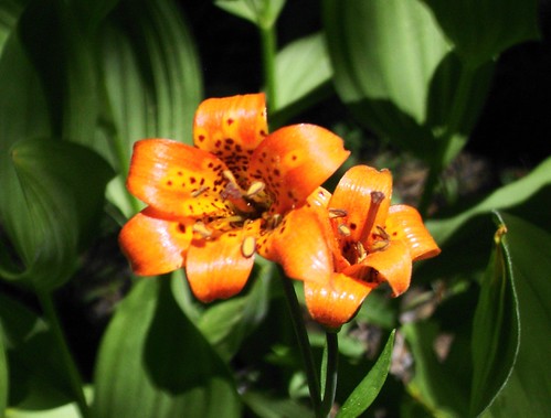
tiger lillies, to
Explorer's Gentian ,
penstamon ,
wild onion , and
Fireweed . We had our first close-up view of our targets at
Shadow Lake , reflected in the calm waters.
The hike to Lake Ediza is truly spectacular, with
cascades plunging down short embankments as the trail winds through the forest. Coming up the final stretch of the outlet, we were met with a strong breeze that ruffled the surface of the Lake and thankfully kept a good number of the bugs away. To the south stood the
Minarets , and the trail wound around the lake to the inlet on the west end. We made
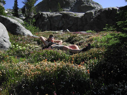
camp p in the same spot as I had last summer, but instead of rushing off to the summit, we decided to have a lazy afternoon. It was a novel concept, and both Charles and myself felt a bit odd about not doing anything except lie by the lake and swat at mossies. I threw in my line, but none of the three fish in Lake Ediza showed any interested whatsoever, so I lay the pole down, found a patch of grass with a granite pillow, and fell asleep.
We later got a great tip from Katy, the Forest Service Ranger patrolling the area, about Cabin Lake, back to the east and up from Ediza. While Charles stayed in camp to read and nurse a banged ankle, I scrambled over the
rocks to look for the lake. Passing tiny
tarns ,
waterfalls full of rainbows, and
meadows full of flowers, I finally did stumble onto an old use trail that led to the
lake beneath the Volcanic Ridge. I made it back to camp in time for
happy hour and
dinner , and then we both headed to bed knowing we had a big day in front of us.
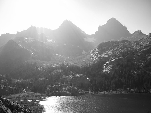
Sunday dawned
smoky , with layers of haze already filtering into the valley to the east, and dimming the sunrise
alpenglow on Ritter and Banner. I clambered up on the rocks at the far side of the inlet to wait for the sun's warmth as Charles got ready for the day, and by 0640 we were headed up the
valley to the peaks. A good use trail heads up from camp, but the trails wind in every direction here, so follow the water. Above the cheery cascades, the valley widens and then steepens to climb to the
saddle between the pair. By 0830 we stood at the base of the glacier, donning
crampons for the final walk up to the saddle. Initially it isn't too steep, and the snow was beginning to soften a bit in the sun, suncups offering respite. A
tongue of snow to the right leads to the saddle, but the
angle was deceiving, as well as the snow quality, which hardened and did not offer as comforting a purchase as the lower section. Charles offered instruction on two-handed technique with my axe, but it was a bit shorter than my other axe and I felt much more off balance. After a dicey 100 feet, we were both sitting on the rock of the saddle, looking up at the
talus to Banner's summit, and also at the
glacier that awaited us on Ritter. But one thing at a time.
From the saddle Banner Peak is fairly trivial, just a talus slog to the top. But once there, the east face drops precipitously to Thousand Island and Garnet
Lakes 3500 feet below. Except for the smoke filtering through the area, we had a grand view in all directions: screaming
eagles to the south signalled the storms to hit Whitney later that afternoon, Mt. Lyell and McClure and
Lake Catherine to the west,
Tuolumne Meadows to the north. I picked up my pack to sit on the broad boulders of the summit, only to watch my helmet decide to commit suicide off the east face! Damn! I wasn't able to dive for it, so someone, someday, is going to have a nice ground score as they climb! We scrambled back down the saddle, and I eyed the glacier on the north face of Ritter skeptically. It just didn't look like snow.
And I was right: the dirt patch in the middle was
scree all right, over a thick layer of ice. We donned crampons once again, and
Charles led the way carefully, looking for deeper purchase and softer snow. We headed up the scree and then to the right, kicking hard but carefully to drive our frontpoints home. A slip
here meant a nice human luge to the waters of Lake Catherine. I chopped a few of his steps more deeply, whimpering audibly as I stepped onto the ice. After a few harrowing steps, I got into Charles' ladder, driving the axe home with a grunt reminiscent of Monica Seles with each thrust and step. Maureen O'Neill said, "Fear deserves recognition but not one iota more of your attention, though it is usually eager to consume all of it." I had a lot of iotas focused in on my fear at that moment, but with head down and boots pointed up, I drove myself to the rock. Shaking at the top, Charles commented on how brave that had been, but we both agreed: we should have had a rope and ice tools.
Back on the rock, we headed west one chute and then up the Class 3
face to the ridge. It was very similar to Middle Palisade in steepness and with plenty of ledges for rest. Because of my lack of helmet, we stayed close or I went first to avoid rockfall. The chute was fun
climbing , without lack of hand or foot folds and textured rock providing plenty of friction. The
ridge dropped sharply to the south and west, the Ritter Lakes shining deep blue at the base of the faces. We turned east up the ridge, ascending to the final, mostly snow-ice filled
chute that leads to the summit. If you've been up Thor Peak, imagine the Smiley Face route on steroids. There was some room in the chute to the left of the snow-ice, but all it provided was loose scree, and the Class 3 rock face to the
outside was broad and comfortable without much exposure, so we switched out and finished it. A short scramble back to the
summit and I was, finally, on top of Mt. Ritter. I let out the call of the Moose with joy, and settled in to the register (which is a mess, btw. There is a book, but lots of loose paper, too). The last piece of paper was the entry from my
friends last summer, and I smiled thinking of where I've been since that time, and what I endured this time around to earn my place next to their names.
Neither of us had any desire whatsoever to descend the way we came, so we picked our way down the SE face to the glacier, following the Clyde variation. The
snow on this side was much more forgiving, but I still felt more comfortable throwing on the sticky-feet while Charles standing-glissaded between deeper sun cups and channels. Water flowed openly on the top of the glacier, cutting a central channel and tumbling into the rock before falling to the valley still 2000 feet below us. We paused to
guzzle more of the purest water on the planet, puckering at the cold. We had heard a
chopper earlier in the day, thinking it might be hovering around the Minarets, but as we dropped below the cliff band above the benches, the CHP made two passes over our heads. Giving them the thumbs-up sign, we watched it circle and then land in the valley, dropping off two teams. (We later met both of them, one of the guys being an acquaintance of mine from Wilson's Eastside Sports in town, who said a backpacker had somehow stranded herself on some Class 3 rock near the base of Ritter.) The rest of the descent was straightforward and benign,downclimbing some Class 3 around the waterfalls, and then a stroll down the valley along the river back to camp.
After breaking camp (and watching masses of people roll into the area), we hit the trail running (well, not literally). The sun had dropped into the smoke, turning the area odd shades of pink and orange, rays of
light streaming from behind the peaks. We dropped to Shadow Lake, pausing briefly to see Ritter and Banner
fading behind the glowing pink curtain of haze. We crossed the bridge over the San Joaquin, marvelled at the mystery and comfort of the dense pine forest, then started the gentle climb back to Agnew. The beacon atop Mammoth Mountain, as well as the first evening star, lit our way home.
A few other moments from the weekend to share:
Rest of the pics are
here .
Charles' pics are
here .
From the luckiest girl in the world: Climb hard, Be safe.
-L


